|
General Questions
What is the San Diego County Plant Atlas?
What is the Goal of the Plant Atlas?
Who is in Charge?
How is the Plant Atlas Being Supported?
How Can I Find Out More?
Parabotanist Program and Training
What is a Parabotanist?
Why Should I Become a Parabotanist?
How do I Become a Parabotanist?
When is Your Next Parabotanist Training?
What is my Responsibility as a Parabotanist?
How Much Time Will it Take to be a Parabotanist?
I am a Professional Biologist - Why Do I Have to Take
Your Parabotanist Training?
I Can't Commit to Taking Responsibility for a Whole Square.
Can I Still Participate?
What if I Don't Know How to Identify Plant?
Do I Have To Buy Expensive Equipment to Participate?
I Want to Photograph Plants as I Go, Do You Want the Pictures?
Plant Collecting
What Plants am I Supposed to Collect?
What Happens to the Specimens?
What is a Specimen Number & How is it Used?
What Do We Do About Sensitive Plant Species?
What is the Difference Between a "Sensitive" Plant and a
"Special Status" Plant?
What is a Naturalized Plant Species?
Recording Field Data
What is the Purpose of Collecting Data in the Field?
What Happens to the Data I Collect in the Field?
How is my Data Used on the Specimen Label?
Do You Proof-Read My Data Before Printing Labels?
What Does a Specimen Label Look Like?
Why Use a Field Book?
What Should I Write in my Field Notebook?
What does "Collection Event" Mean on the Online Data Entry
Form?
What Do I Write Down for "Locality"?
What Do I Write Down for "Others in Team"?
What Do I Write Down for "Latitude/Longitude"?
What Do I Write Down for "Elevation"?
What Do I Write Down for "Vegetation"?
What Do I Write Down for "Geology"?
What Do I Write Down for "Phenology"?
What Does "Number of Labels for Mounting" Mean on the Online Data
Entry Form?
What Do I Write for "Description of Plant"?
Why Do I Need to Worry About Writing Descriptions of
the Collecting Location When I Gave You the Coordinates?
Data Entry and Editing
What Are My Login Initials and Password, and What Are They Used For?
Who is "jr" and What is He Doing In My Square?
Submission of Plant Specimens
How Do I Submit My Plant Specimens to the Museum?
Why Did the Plant Specimens I Submitted Get Rejected?
Atlas Grid Squares
What is an Atlas Grid Square?
Why Are Some Grid Squares Not Square?
How Can I Find Out How Many People are Working in A Grid Square?
How Do I Choose A Grid Square?
Coordinates and GPS
How Does Latitude and Longitude Work?
Can You Explain How to Find Coordinates for My Collecting Location?
What Coordinate System Should I Use for Latitude and Longitude?
Aren't "Degrees, Minutes, Seconds" and "Decimal Degrees" the Same?
Do I Need to Buy a GPS Unit?
How Accurate is my GPS?
How Do I Set Up My GPS Unit Properly?
If I Use My GPS, Do I Still Need to Mark Locations on a Map?
Why Do I Need to Mark My Collecting Locations on a Map?
How Does a GPS Work?
What is Differential GPS (DGPS)?
What Does NAD 27 or NAD 83 Mean?
How Do I Enter My Collecting Location Coordinates into the Data
Entry Form?
How Will I Know if My Latitude and Longitude are Wrong?
What are the Boundaries of Latitude and Longitude for My Grid
Square?
Why Did I Get an Error Message When I Entered my Coordinates
into the Online Data Entry Form?
Can I Use My GPS to Get the Elevation?
How Should I Record Elevation in the Field?
Volunteer Opportunities
What if I Cannot Do Field Work? Can I Still Participate?
General Questions
What is the San Diego CountyPlantAtlas?
The San Diego County Plant Atlas will scientifically document the floristic diversity
of San Diego County by initiating the collection of plant specimens using a grid system
covering the entire county. The project has been designed to provide more accurate
and detailed geographic information on the flora of the San Diego County for science,
education, the interested public, and land managers. Back
to FAQ List
What is the Goal of the Plant Atlas?
The purpose of the Plant Atlas Project is to scientifically document the floristic
diversity of San Diego County by collecting voucher plant specimens. The long-term,
overall goal of the project is to provide the SD Herbarium at the SDNHM with one specimen
of each native or naturalized plant species that grows in each atlas grid square.
To accomplish this, we have created a "parabotanist program"
to train interested members of the community how to properly collect plant specimens
and record appropriate field data, and we've developed a streamlined system for them
to deliver the specimens and data to us. Back
to FAQ List
Who is in Charge?
The San Diego County Plant Atlas Project is being directed by the San
Diego Natural History Museum (SDNHM) and is undertaken with the full support of
the Museum's administration and board of trustees. The Curator of Botany is Dr. Jon
Rebman, and the Plant Atlas Director is Dr. Mary Ann Hawke. Jeannie Gregory is the
Parabotanist Manager. An Advisory Committee composed of representatives from various
government agencies (including the City and County of San Diego ) and conservation
groups provides guidance and oversight. Back
to FAQ List
How is the Plant Atlas Being Supported?
The Museum will be raising money from many sources to fund the Plant Atlas. To date,
the Botany Department has received some funding from The San Diego Foundation, San
Diego County Department of Parks and Recreation, California Department of Fish and
Game, California Department of Parks and Recreation, and the San Diego Chapter of
the California Native Plant Society. This initial funding is being used to contribute
to the cost of developing the new online data submission system and database, creating
the novel parabotanist program, training the volunteer parabotanists, and to help
pay for some equipment and supplies. Volunteers are providing the voucher plant specimens
and field data. Back
to FAQ List
How Can I Find Out More?
Please refer to our Plant Atlas news and general information pages posted on the SDNHM
website at www.sdnhm.org/plantatlas Back
to FAQ List
Parabotanist
Program and Training
What is a Parabotanist?
A parabotanist is an official volunteer of the San Diego Natural History Museum who
has undergone our training and who collects plant specimens and data for the SD Herbarium.
You do not have to be a formally trained biologist or botanist to become a parabotanist.
Professional botanists are also encouraged to contribute to the Plant Atlas project,
as long as they participate in our mandatory training. There are other ways to contribute
to the Plant Atlas, other than joining the Parabotanist Program and taking the parabotanist
training (Look under "Volunteer Opportunities"
below). Back to
FAQ List
Why Should I Become a Parabotanist?
Participating in the Parabotanist Program allows you to become a contributor to an
important research project that scientifically documents the floristic diversity of
San Diego County . It introduces you to the scientific fields of floristic and taxonomic
research, and trains you how to conduct field work and collect scientific data. Through
your association with the SDNHM, you will have the opportunity to learn more about
the unique natural history of the County and study the flora of the region in detail.
Many botanical specimens in the SD Herbarium were collected as far back as the 1800's
by now famous botanists, thus becoming a part of County history. Like those, your
specimens will also be Back
to FAQ List
How do I Become a Parabotanist?
In order to do field work and collect plants for the Plant Atlas (i.e., become a parabotanist)
you must attend a mandatory training session taught by the Botany Department at the
SDNHM. The training will give an overview of the project, and cover topics such as
the floristic diversity of the county, the atlas grid square system, field equipment
used for plant collecting, reading maps and finding coordinates, and will discuss
what books and resources are available to help. The training will also teach you how
to do the following: collect and press museum-quality plant specimens; collect data
in the field and keep a field notebook; use our online system to submit your data;
deal with issues like special status plant species, access to property, permits, safety
etc. Since the project relies heavily on web-based applications, you must feel comfortable
using a computer and working online. Having your own computer is desirable, although
you will be able to access all our support materials and our online data submission
forms via the Internet from a public library, or a friend's computer. Some strenuous
physical activity may be required in order to participate in collecting plants in
the field; however, you may also be able to contribute to the Plant Atlas in other
ways besides participating as a parabotanist (see the related FAQ under "Volunteer
Opportunities" below). Back
to FAQ List
When is Your Next Parabotanist Training?
A schedule showing the dates of upcoming parabotanist training can be found by clicking
here. Parabotanist Training Schedule Back
to FAQ List
What is my Responsibility as a Parabotanist?
If you decide that you want to become a parabotanist (i.e., do field work and collect
plants as part of the Plant Atlas project) you will be responsible for the following:
attending the mandatory training; reading and following the instructions provided;
adopting all or part of a grid square in which to focus your collections; abiding
by any permit requirements; acting as a responsible representative of the SDNHM; contributing
to our long-term, overall goal which is to provide the SD Herbarium with one voucher
plant specimen of each native or naturalized plant species growing within each atlas
grid square; visiting your grid square during different seasons and different years;
entering your field data in a timely manner via our online data submission system;
submitting your dried and pressed plant specimens to the SD Herbarium; conducting
yourself safely and responsibly when doing field work. You may occasionally be required
to perform strenuous physical activity if you choose to participate in plant collecting. Back
to FAQ List
How Much Time Will it Take to be a Parabotanist?
Everyone officially collecting plants for the Plant Atlas must commit to completing
the mandatory parabotanist training (a minimum of 3 hours) and that includes professional
biologists and botanists. Some parabotanists may want more training and decide to
attend the 2-hour refresher class in the field. Beyond that, the time commitment varies
from person to person depending on where you choose to do your collecting and how
often you decide to work on it. Some parabotanists are adopting and covering entire
grid squares, while others are sharing the workload within teams. Some will focus
only on limited areas where they have special access arrangements, like their own
property. Remember that you are being asked to contribute to the long-term, overall
goal of the museum, which is to have in its herbarium one specimen of each native
or naturalized plant species growing in each grid square. Different plants flower
and fruit at different times of the year (and some years are better than others) so
obtaining good quality, reproductive plant specimens will clearly take many field
visits over a number of years (the Plant Atlas is at least a 5-year long project).
Generally one hour of focused collecting time in the field (e.g., obtaining about
20 plants) leads to at least two more hours at home, spent processing and pressing
the plants, and then doing the online data entry. It may take even longer, depending
upon how much time you decide to devote to learning to identify the plants. Back
to FAQ List
I am a Professional Biologist - Why Do I Have to Take Your Parabotanist Training?
We respect and appreciate the fact that the Plant Atlas has had such a positive response
from professional biologists and botanists. Your contributions and enthusiasm have
already proved to be a great asset to the project and we want you to continue to be
involved. The purpose of our instruction is to teach the art of taking comprehensive
field notes and the craft of preparing museum-quality specimens on which to base further
scientific study. The practical reasons that we require everyone officially collecting
plants for the Plant Atlas project to go through our training program (despite your
varied backgrounds, experience, and level of knowledge) include the following: • We
have developed some very specific procedures for collecting and pressing plants and
recording and submitting field data that may be different from what you are used to
doing. For the sake of consistency, we need all participants to be "on the same page"
with respect to these procedures; • We need everyone to understand clearly what they
are being asked to do, and what not to do; • We want the Agencies to be comfortable
that we are consistently providing all of our volunteers with certain information
(e.g., about permits, access, safety, and special status species); and • We have expended
considerable effort making special arrangements with some of the Agencies to obtain
collecting permits that are issued to the SDNHM and cover all parabotanists working
on their land. However, you must undergo the training in order to meet the permit
requirements. • Besides all that, completing the parabotanist training allows you
to become an official volunteer of the SDNHM and enjoy the benefits that come with
it, including a 20% discount in the Museum Store (whereas regular museum members get
a 10% discount). Back
to FAQ List
I Can't Commit to Taking Responsibility for a Whole Square . Can I Still
Participate?
Absolutely! If you prefer to cover only your own property, neighborhood canyon, or
favorite hiking spot, that is fine. Your collections can contribute substantially
toward the data for that square even if someone else takes primary responsibility
for covering it. Teaming is encouraged. Most people will be glad to have some company
in the field and have help with planning, driving etc. If you don't already know who
you are sharing a grid square with, or how to contact them, you can find out by logging
into the parabotanist website and selecting "Who's In A Square ". Back
to FAQ List
What if I Don't Know How to Identify Plants?
The ability to identify plants is not a requirement! Professional botanists will verify
the identity of all plants submitted. You are encouraged to try to learn the families
and names of plants you have collected if you wish, and to go ahead and enter that
information into the online data submission form. If your guess is not right, the
botanist will write in the correct name on the specimen label before it is filed in
the herbarium.
One of the benefits of volunteering as a Parabotanist is that your plant identification
skills will probably improve as you go along. After you turn in your specimens and
they are reviewed by a botanist, you will be able to check online to see if your identification
was correct, or if not, what the correct identity of each specimen is. Back
to FAQ List
Do I Have to Buy Expensive Equipment to Participate?
No. Plant collecting has been successfully carried out through history using only
the most basic technology. We regret that our current level of funding means that
for the most part parabotanists will have to supply their own equipment and materials.
Fortunately, an adequate setup can be put together from simple materials, or fancier
gear may be purchased. Give us a call at 619.255.0298 or email us at plantatlas@sdnhm.org for
more information about getting supplies like plant presses and field notebooks. For
more information about field equipment and supplies, you can print out this handout
"Equipment and Supplies for
Plant Collecting" that we have prepared. Back
to FAQ List
I Want to Photograph Plants as I Go, Do You Want the Pictures?
We're not presently able to accept photos, but hope to add this capability in the
future. We will want them in digital form, either from a digital camera or scans of
prints. When we do begin accepting photographs, we will require
the file name to match the index number of the specimen. (The index number is made
with your login initials, a "#" symbol, and your specimen number.) So, for example,
a filename might be jfs#475A.jpg. This will ensure linking the photo to the specimen
for correct identification of the plant in the picture. Back
to FAQ List
Plant
Collecting
What Plants am I Supposed to Collect?
The goal of the Plant Atlas is to provide the SDNHM with one voucher specimen of each
native or naturalized plant species that grows in each atlas grid square. Naturalized
plants are those introduced species that have escaped into our natural areas and successfully
grow in our canyons or backcountry without any help from us. You are being asked to
collect both native and non-native plant species but not plants that are being grown
horticulturally (like roses or daffodils etc.). Think of it this way - you mustn't
collect plants that were planted by people (in lawns, parks, gardens, or along roadsides,
for instance) or are on "life support" (like artificial irrigation). The reason for
collecting non-native plants is that we are interested in finding out about new plants
that are arriving in our County and becoming established here, because they may end
up becoming problem weeds or "pest plants" of some kind. Back
to FAQ List
What Happens to the Specimens?
Specimens collected for the San Diego County Plant Atlas Project will be deposited
in the herbarium of the San Diego Natural History Museum, where they will be available
as permanent vouchers for the Plant Atlas, to allow future verification of the identifications,
as well as updates as taxonomic changes occur. In addition these specimens will be
available to researchers and botany enthusiasts. Back
to FAQ List
What is a Specimen Number? How is it Used?
Biologists use a system when collecting their specimens that assigns a unique number
to each specimen. This is done so that the information recorded in their field notebook
can forever be linked to the specimen. You write the specimen number in your field
notebook along with the data recorded about the specimen and its location. Your specimen
number must be in the form of an integer and an optional one-letter suffix from A
to F. (Examples: 5, 5B, 264, 5844E) You enter the specimen number and the optional
suffix into the data entry form on the web.
When you enter data, the database creates a new number, the Index Number, that assures
each specimen is uniquely identified. The index number is created by using your login
initials, a "#" sign, and your specimen number. A typical Index Number might be: jk3#734
or mf#32A. You also write that same Index Number on the outside of the newspaper holding
the specimen (write it on the top, outside edge of the newspaper, facing outwards).
Don't forget that if you change the newspaper during the pressing and drying process,
you need to transfer that collection number to the fresh newspaper as well. Back
to FAQ List
What Do We Do About Sensitive Plant Species?
Do NOT collect any sensitive, or special status plants! If you do not know how to
tell whether a plant may have special status or not, we have many resources available
to help you. Make an appointment (by calling 619.255.0298 or 255.0229) to visit our
herbarium at the SDNHM and look at the synoptic collection of sensitive plants for
the County. We also have available a photo album with excellent color pictures and
summary information on the sensitive plants of the County that was specially prepared
for us by local photographer Marsha Hanson. The California
Native Plant Society (CNPS) published an "Inventory of Rare and Endangered Plants
of California" in 2001 that includes plenty of good information;
however, it doesn't provide photos or help on identifying the plants. Finally, when
you adopt a grid square, your handout packet on that square will include a printout
of those special status plant species that have already been officially reported to
occur in your square. Included in the list are those special status plants that have
not yet been reported, but may be observed in your square. To familiarize yourself
with the special status plants reported in your square, use the main resources mentioned
above, or do an Internet search of the plant name. There is a lot of information about
these plants available online. Back
to FAQ List
What is the Difference Between a "Sensitive" Plant and a "Special Status" Plant?
The main difference is the legal definition. "Special Status" plants are legally protected
under the Endangered Species Act (either the Federal ESA, the California ESA, or both).
Through an official petition process, plants may be "listed" as "Threatened" or "Endangered"
under these laws and it is generally illegal to destroy or "take" (i.e., kill) a species
once it becomes officially listed. On the other hand, "Sensitive" plants may be rare,
at risk, or very limited in their distribution, but they have not attained
any official protection under the law. The California Native
Plant Society (CNPS) published an "Inventory of Rare and Endangered Plants of
California" in 2001 that has plenty of information about the status of these plants
and the CNPS website also has a section devoted to
rare plants. These both describe how CNPS has developed its own system of five "lists"
to describe the status of
California
native plants. If you are interested in learning more about the legalities of native
plant protection in California, here is a link to the special issue of the scientific
journal Fremontia (2001,
Volume 29:3-4) devoted to this topic. Back
to FAQ List
What is a Naturalized Plant Species?
A naturalized plant species is one that has become established in a region where it
had not previously lived so that it becomes an established part of the community,
successfully reproducing and competing with native species. In San Diego County, some
familiar examples of naturalized species that we see in our urban canyons include
the following: the Canary Island Date Palm (Phoenix canariensis), Scarlet Pimpernel
(Anagallis arvensis), Wild Radish (Raphanus sativus), Short-Pod Mustard
(Hirschfeldia incana), Geraniums (Pelargonium sp.), or the brome grasses
such as Ripgut Grass (Bromus diandrus), Soft Chess (B. hordeaceus),
and Foxtail Chess (B. madritensis ssp. rubens).
To find out whether or not that plant you've found is native or naturalized, please
refer to "The Checklist of the Vascular Plants of San Diego County" by M.G. Simpson
and J.P. Rebman (3rd Edition, 2001) which is also available online [here].
Naturalized plants are identified in the Checklist by the asterisk (*) before their
name. Back
to FAQ List
Recording Field Data
What is the Purpose of Collecting Data in the Field?
Your plant specimens will be permanently housed in the SD Herbarium for many decades
to come, long after San Diego County has changed in appearance. Researchers from all
over the world will use our herbarium and our botanical data. Your job is to convey
to those researchers exactly what you saw around you as you collected the plant specimen.
You are their eyes, and you must remember that they may not be familiar with local
vegetation or place names. So you must "draw a picture" in their mind's eye of what
the plant was like when you collected it, and describe where you were, and what else
was there at the time. For example, was the plant tall, short, erect, sprawling, branched,
or not? Was it growing in a grassland, or woodland or some other habitat? Was it growing
in water, or in sand, on a mudflat, or on a rock outcrop? Was it growing on a steep
cliff face, or a gentle slope, or in a swale? Was the slope
facing north or south? What was the exposure like (e.g., exposed or shaded)? What
were the dominant plant species growing with it? Was it a parasitic plant and if so,
what host species was it growing on? What was the closest major city and landmark?
All this is the kind of information that can help describe the specimen and its surroundings
to people in the future. Back
to FAQ List
What Happens to the Data I Collect in the Field?
You are responsible for submitting the field data to us using the online
data entry form that we have mounted on our website. The data that you record
in the field when you collect your plant specimen is used in two ways: 1) it is printed
on the label that is affixed to the herbarium sheets along with your specimen so that
someone looking at the specimen in years to come can read about where it was found,
who collected it, when it was collected, and what type of habitat it was growing in
etc.; 2) after the identity of the specimen has been verified by the professional
botanist, the data are stored into a permanent database. The database is searchable,
so that other parabotanists (and the public) can find out what species have been collected
in different grid squares. The database may also be used by researchers who are studying
the floristics of the county, or by students and teachers etc. Back
to FAQ List
How is my Data Used on the Specimen Label?
Be aware that the information that you type into the online data entry form will appear
(along with your name!) on the printed label that is glued to each herbarium sheet
exactly as you enter it (please read the related FAQ "Do You
Proof-Read My Data" below). Please remember that these labels will be read by
people from all over the world for generations to come, so do the best you can to
be concise and accurate. Do not use slang or short-form words, or put "I don't know"
- it is better to leave a field blank than to put in ?? or "unknown" etc. For example,
when you enter "Others in Team" under the collection event, don't put "my gardener",
or "my dog Spot" - use either full names, or initials and last name. Try to avoid
exclusive use of vague localities (like "Sycamore Canyon" of which there are several
in San Diego County) or historical place names (like Dubber, for example). Do not
use names that may be known only to locals (such as "Reed's Mine" or "Scissors Crossing")
as stand-alone descriptions without including more detailed information such as the
name of the closest town or natural feature like a mountain
or lake (please see the related FAQ "What Do I Write Down for
Locality" below). Finally, do not refer to landmarks that are not likely to be
there in decades to come (e.g., "near the old red barn on Post Road ", or "the old
field beside the hardware store"). Try to use concise language. For example if you
wrote down "above Little Clark Lake" the reader unfamiliar with local geography may
not understand whether you meant to say "on hillside at 2000 ft elevation above Little
Clark Lake" or "north of Little Clark Lake". Back
to FAQ List
Do You Proof-Read My Data Before Printing Labels?
No - the data on the label that will be attached to your specimen for a century or
more to come will be exactly as you typed it into our database over the internet.
We may contact you if the data you enter seems to be contradictory or erroneous, but
we don't correct spelling, rewrite text, or check for accuracy
of details. While we are able to help you by identifying your plant for you, we cannot
edit your field data because we were not there and don't know what you saw. So please
make sure your entries are as clear, complete, and accurate as possible. Back
to FAQ List
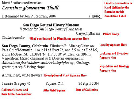
What Does a Specimen Label Look Like?
The specimen label is about 4.25 in. wide by 4 in. tall and it is fixed to the bottom
right corner of the 11 in. by 17 in. herbarium sheet on which the plant is affixed
with glue. Here is an example of what our labels look like, to give you an idea where
the information you submit to us ends up. Back
to FAQ List
|
|
Why Use a Field Notebook?
We recommend that you get into the habit of using a field notebook to record your
observations, rather than jotting them down on pieces of paper on a clipboard. Using
a notebook is like keeping a journal, it keeps the events in chronological order,
keeps them from getting lost or jumbled, and provides a quick
refresher of where you left off the last time. A small, hard-cover bound notebook
is sturdy enough to be lugged around on hikes and can fit easily into your pack or
pocket. You can tape or write important information inside the cover for quick reference
(like a printout of a field data form, or a map). You can photocopy the contents of
your notebook and keep that record in a safe place. Back
to FAQ List
What Should I Write in my Field Notebook?
People are going to differ on the level of detail that they like to record in their
field notebook, depending on their experience, training, and personality. That said,
here is some essential information that you should always write down each day that
you go out collecting (because this is what you are going to be required to enter
into the online data entry form later). Each day, record the date, the grid square
you are in, the members of your team (if applicable), and the number of hours spent
(you will be asked to report your volunteer hours when you submit your specimens).
The following is the minimum information to record about every collection event (or
collecting location, if you prefer that term): Locality, Latitude/Longitude, Elevation, Vegetation,
and Geology. This is what you need to record about every specimen
that you collect: Specimen Number, Phenology (i.e., is it flowering,
fruiting, vegetative? etc.), and Description of Plant.
If you have an idea what plant family the specimen belongs to, or what the Latin or
common name is, you may write that down as well (although you may need to look that
up later with the help of books or the Internet, or we will identify it for you after
you bring in the specimen). If you don't understand what we are asking for, there
are other FAQs below that define each of the fields on our online data entry form. Back
to FAQ List
What does "Collection Event" Mean on the Online Data Entry Form?
We ask you to collect field data of two different types. We need information about:
1) your collecting location; and
2) your plant.
You can see that the online data entry form is also divided into two parts:
1) Common Data for the Collection Event (i.e., information about the location); and
2) Specimen Details (i.e., information about the plant).
On any day, you may collect more than one plant at the same basic location - in other
words, the location information may be identical for several different plant specimens.
We set up the online form so that you don't have to enter that same location information
over and over again. Think of it this way. When you stop at a good spot to collect
some plants and write down the information about that location - that is your first
"collection event" (or collection location, if you prefer that term) of the day. So
write in your notebook "Location #1" and the details (such as locality, lat/long coordinates,
elevation, surrounding vegetation, geology etc.). Proceed to collect your specimens
in that location and record a collection number for each plant (along with the details
about the plant itself). As soon as you hike away from that location, and factors
like the slope, elevation, aspect, surrounding vegetation type, geology, or latitude
and longitude change significantly, you will know that you have moved on to a different
"collection event" (collecting location) and you will need to write down the details
(like locality, lat/long coordinates, elevation, surrounding vegetation, geology etc.)
all over again. That will now become "Location #2" in your
notebook. When you move away from there, and conditions change again, then that will
become the next "collection event" and you will call that "Location #3" and write
down the information describing that site, and so on. Back
to FAQ List
What Do I Write Down for "Locality"?
Write down a description of where the collection site is located. Remember that when
your specimen is part of the museum's herbarium, it will be used by researchers who
may be from anywhere in the world, who are not familiar with the Plant Atlas project
or with this region, and who may not speak English very well. You need to include
enough information for them to be able to find the approximate location on a map and
go to the same general area; it doesn't have to be so detailed that they can find
the same plant you collected from.
The label will automatically say " San Diego County, California :" followed by whatever
you type into the Locality box on the online data entry form. You should begin with
a general landmark (preferably one listed on a standard topographic map) such as the
name of the closest town/city, or a natural feature like a mountain or lake. After
that, include additional detail adequate for other people to find the general area
where you collected the specimen. If you know the plant was collected on public lands,
you should include the name (for example, Anza-Borrego Desert State Park , or Cleveland
National Forest ). You should avoid landmarks that can't be expected to exist a few
decades from now ("end of pavement on Suchandsuch Road") or that are meaningful only
to you ("north pasture on Gibson ranch"). Or how about that classic San Diego landmark,
"where the old Sears used to be"?
Here are some examples of well-written localities (note - ca. is short for "circa"
which means "approximately"):
-
Descanso, mile north of Hulburd Grove, on sandy bank, west edge of Sweetwater River.
-
Elizabeth R. Mining Claim on Pala Chief Mountain. ca. 1 mile north of Hwy. 76, and
3.5 miles east of I-5, along Magee Rd.
-
Coronado, alley between B and C Avenues, and between 7th and 8th Streets.
-
Near hiking trail, just east of Oak Canyon, ca. 1.5 mile north of trailhead at Hwy.
83 and Ventura Rd., Pickwood State Reserve.
Back to FAQ
List
What Do I Write Down for "Others in Team"?
If you go out collecting with other people, record their names (either first and last,
or initials and last name). Once entered into the online data entry form, this information
is printed on the specimen label exactly as you enter it, so don't put down things
like "my uncle", or "my dog Fido", or "Steve" that won't be meaningful to some international
visitor to the herbarium 100 years from now. Back
to FAQ List
What Do I Write Down for "Latitude/Longitude"?
You need to record the coordinates of each collecting location (collection event)
accurately. Coordinates are necessary to enable searches of the database by location
(and you can't search on a description like "3 miles east of Campo") and they are
also commonly used to map known occurrences. In other cases, a future researcher (possibly
someone from another country who isn't familiar with local place names) may have a
reason to go back to the same area that you collected your plant. We use latitude
and longitude, recorded either as "degrees, minutes, seconds" OR as "decimal degrees"
to report locations. Our database does not support the use of UTM coordinates. If
you use decimal degrees, please record no fewer than 4 decimal places of precision
(i.e., at least 4 numbers after the decimal place). If you use a hand-held GPS to
determine coordinates, please set your default datum to NAD 83/WGS 84 (not NAD 27).
For more information on collecting location information correctly, please see "How
does Latitude and Longitude Work?". Back
to FAQ List
What Do I Write Down for "Elevation"?
Record the elevation of each collecting location in either feet or meters (there is
a feet-to-meter converter available on the online data entry form). Unfortunately,
Topozone no longer provides elevation information for free
so you must either obtain elevation from your GPS, or estimate it by using the contour
lines on a topographic map. Contours are lines on a map that connect points of equal
elevation and help describe the shape of the land. USGS quad maps (and your color
topographic map that was included in your handout packet) show contours at intervals
of 20 feet. Back
to FAQ List
What Do I Write Down for "Vegetation"?
While you are out in the field, you need to look around you and record information
describing the dominant vegetation that surrounds the plant specimen you just collected
(note that the details about the specimen belong elsewhere on the form - see the related
FAQ below "What Do I Write for "Description of Plant"?).
Once it is mounted by itself on its herbarium data sheet, nobody can tell what was
originally growing along with this specimen, so you must write that down for the benefit
of those people (who may even be from another country) many years from now who were
not there with you at the time you collected it. For our purposes, you may record
a general community/vegetation type (e.g., chaparral, coastal sage scrub, riparian
scrub, oak woodland, freshwater marsh, non-native grassland, etc.). To help you, here
are some commonly used terms with their definitions shown in brackets: forest (closed
trees), woodland (open trees), chaparral (closed, evergreen shrubs), scrub (open to
sparse shrubs), marsh (aquatic shrubs and/or herbs in slow-moving water), swamp (a
wetland dominated by woody plants such as trees or shrubs), fen (a marshy, low-lying
wetland covered by shallow, usually stagnant water that originates from groundwater
sources), bog (poorly drained, acidic wetland primarily composed of dead sphagnum
moss), meadow (an area covered primarily with grass). Be aware that this information
will appear on the printed label on the herbarium sheet exactly how you enter it into
the online data entry form. Here are some good examples that give a general vegetation
type plus some of the dominant species:
-
"Mixed chaparral with Quercus engelmannii, Adenostoma fasciculatum, and Arctostaphylos sp."
-
"Disturbed area with Camissonia bistorta, Pectocarya linearis, Vulpia myuros, Brassica
nigra, and Larrea tridentata"
-
"Riparian scrub with Salix lasiolepis, S. gooddingii, Pluchea sericea, Populus
fremontii and Platanus racemosa.
Do not include information about the soil (substrate) in the online data entry form
field called "Vegetation" - that belongs in the next field called
"Geology" (see explanation below). If you choose to be very precise, and want to learn
more about writing up detailed field notes, you may refer to the "Plant Collecting
and Documentation Field Notebook" written by SDSU Professor Michael G. Simpson in
1997. It is available in the Museum Store (where you will get a 20% discount as a
parabotanist) and includes very well-written and detailed instructions about recording
field data. Back
to FAQ List
What Do I Write Down for "Geology"?
While you are out in the field, you need to look around you and record information
about the physical habitat (substrate) that the plant specimen you just collected
was growing in. To us, "Geology" refers to abiotic features (abiotic means non-living,
physical factors like soil type, moisture, etc.) and may include things such as "dry
creek bed", "granite outcrop", "flood plain", "mudflat", "sand dune" etc. It may also
include key information about local topography like slope and aspect (e.g., "steep
S-facing slope" or "toe of NW-facing slope") or exposure (e.g., exposed, partly shaded
or shaded). If you are knowledgeable about soil, and know how to determine the soil
texture from the proportion of sand, silt, and clay (e.g., medium sandy loam, fine
silty clay, coarse loamy sand, etc.) You may record that but it is not necessary.
Similarly, if you are trained in geology and know how to determine what the "parent material"
is (e.g., granitic, basalt, sandstone, shale, gabbro, alluvium, etc.) go ahead and
record it but it is not necessary. Do not include information about vegetation in
the field for "Geology" when you enter your data online. If you are really interested
in learning more about the geologic history of the county, you may want to read Pat
Abbott's book "The Rise and Fall of San Diego" that is available in the Museum
Store. Back
to FAQ List
What Do I Write Down for "Phenology"?
On our online data entry form, Phenology is a drop-down box, meaning that you get
to select from a list of options that appear when you click on the arrow. The choices
include flowering, fruiting, fruits and flowers, vegetative and unknown. So if your
plant specimen had flowers and/or fruits then record that information. If it was vegetative
(no reproductive structures visible) then write that down. Back
to FAQ List
What Does "Number of Labels for Mounting" Mean on the Online Data Entry
Form?
Sometimes people collect more than one specimen of a particular plant, usually because
they want to submit one to the SD Herbarium and then give one or more away to other
collections. So usually, you would simply leave this at the default value (one label),
unless you are bringing in more than one to be mounted. Back
to FAQ List
What Do I Write for "Description of Plant"?
When you remove the plant from the collecting site, some information that seems obvious
at the time may be lost, especially if you are only taking a sample of the whole plant
(e.g., clipping branches from a tree or shrub). Similarly, some details (like flower
color) may fade or change appearance over time so they need to be recorded at the
time the plant is collected. You should make note of the Phenology (is the plant flowering
and/or does it have fruit on it?), the habit (is it a herb, shrub, subshrub, vine,
tree, bulb or tuber?), the duration (annual, biennial, or perennial), the height from
ground level (if you only took part of the plant), and any distinguishing
features of the branching pattern that are not apparent from
the specimen itself. Be sure to describe any obscure features, or those that may be
lost once the specimen is dried and mounted. If it is a parasitic plant (like dodder
or mistletoe) please include the host plant as part of the specimen, and make note
of the host (e.g., "parasite on Artemisia californica"). Remember that you
must report what you see before you to the person who is standing in the herbarium
later, holding onto your mounted specimen. Was the plant erect, or sprawling? Was
it a parasitic plant and if so, what host species was it growing on? If it is a grass,
was it growing in tufts, or was it spreading? If it is a cactus, how many ribs were
there on it? And so on. Back
to FAQ List
Why
Do I Need to Worry About Writing Descriptions of the Collecting Location When I Gave
You the Coordinates?
-
Coordinates may be wrong. This may be for many reasons including the following: typographical
or transcription errors; incorrect use of a hand-held GPS (including the error inherent
in GPS technology, or having the defaults on the GPS improperly set, or not acquiring
enough satellites, or not having a clear unobstructed view of the sky, etc.); or incorrect
conversion from one coordinate system to another (e.g., incorrectly assuming that
32° 49’ 49” N equals 32.4949° N).
-
Online public searches of the database do not include details of latitude/longitude.
It is feasible that someone may only have the locality description that you write
(that is printed on the label) to guide them.
-
Different maps use different coordinate systems, or a different datum. You recorded
latitude/longitude using the NAD 83/WGS 84 datum but if the person trying to find
your point location has a map in their hand that only uses NAD 27 (or UTM coordinates)
they won’t find the correct location.
-
Places change over time. Nature and human activity alter the landscape, sometimes
dramatically. Even if you do provide accurate coordinates, what if the researcher
who has your specimen is living 20 or 50 years in the future? Even if they used a
GPS to take them to the precise spot you made your collection, don’t you think it
might have changed by then? If you hadn’t recorded the existing conditions at the
time you collected, and if it weren’t printed on the specimen label, that information
would be lost to future generations.
-
We send our plant specimens out on loan to researchers all over the country and the
world. They will only have available the information printed on the label. A researcher
in Florida or Sweden may not have a detailed topographic map of our area, although
they could probably quickly locate a town, city, state/national park, or a landmark
like a mountain, lake, or reservoir. So a good description (e.g., “Pickwood State
Reserve, ca. 4 miles NW of Wilson Peak, ca. 1.5 miles N of trailhead at Hwy 83 and
Ventura Rd.”) would probably help them quickly place their finger on a map, without
even having to use the coordinates.
-
Coordinates together with good locality descriptions provide “multiple lines of evidence”
that improve the confidence level in our dataset. Having a complete description of
the collecting location provides more evidence to help narrow down the location. If
the coordinates and description match, then we know that we can have high confidence
in the quality of the location data. (Conversely, if the description doesn’t match
with the coordinates, then we will be alerted that there are inconsistencies in your
data.)
By the way, this ties directly into why it is so important to use your words to paint
the whole picture for that future researcher who is holding your specimen in their
hands. It is also the reason why the data entry form has fields for locality, vegetation,
geology (i.e., terrain and soil), elevation and latitude/longitude – any one of those
by itself is insufficient. Even the most accurate coordinates do nothing more than
allow someone to put a dot on a map. Depending on what kind of map they are using
(a street map, a topographic map, etc.) coordinates can give them only half of the
picture (unless they have access to a sophisticated GIS system that can provide information
about vegetation, topography, elevation, soils, etc.). The other half of the picture
is your description of the terrain because that tells them where the plant was growing
and what the conditions were (e.g., mountain slope, ca. 30 degrees, south-facing,
exposed, near hiking trail. Elev. 350m, Rocky, sandy loam soil). Back
to FAQ List
Data Entry and Editing
What Are My Login Initials and Password, and What Are They Used For?
Once you have completed the mandatory parabotanist training, we will tell you what
your login initials and password are. You will need to use these to log in to our
website when you are ready to enter your field data online (e.g., look at the login
page here). Your login initials
will usually consist of the first letter of your first and last name,
and may include a number if others share the same set of initials with you (e.g.,
if more than one parabotanist has the initials jg, then there may be a jg, and a jg1
and a jg2 etc.) Your login initials are also used by the database to make the Index
Numbers for your specimens. Back
to FAQ List
Who is "jr" and What is He Doing In My Square?
The answer is that "jr" stands for Jon Rebman (Curator of Botany at the SDNHM) and
it is quite likely that he may have been collecting at one time or another in your
square. Part of your routine as a parabotanist should be to check in to our website
before you go out in the field collecting, and read over (and/or print out) the list
of specimens that have already been collected in your square so you don't
duplicate the effort (to do that, click on "Search the Database" on our website and
enter the grid square that you wish to search). Look at the column labeled "index"
to see the collection numbers, which include the initials of the collector. You may
be surprised to find that a large number of specimens have already been collected
in your square by the mysterious "jr", even before you get started! Back
to FAQ List
Submission
of Plant Specimens
How Do I Submit My Plant Specimens to the Museum?
Make certain that you have entered the field data online before bringing your specimens
into the museum (the data are needed to print out the labels that go with your specimens).
Specimens may be delivered (by appointment) during working hours Monday through Thursday
or they may conveniently be dropped off at the Front Desk (at the North Entrance of
the Museum) whenever the Museum is open (including weekends). Stack your completely
pressed and dried plants (each plant still inside its own newspaper showing its
unique collection number) with a few sheets of cardboard for support, and tie the
bundle up loosely with string. Be sure to fill out and include on the top of
the bundle a "Collection
Data Sheet and Record of Volunteer Hours" form. The form is available at the Front
Desk, or you can find it on our website and print one out. Please record on the sheet
the hours you spent in collecting and preparing that particular group of specimens,
and the range of collection numbers included in the bundle. Back
to FAQ List
Why Did the
Plant Specimens I Submitted Get Rejected?
All the plant specimens that are submitted to us are carefully examined by our staff,
and the identities are verified (and if necessary, corrected) by a professional botanist.
Especially if you are learning to collect plant specimens for the first time, you
may find it most useful to enter the data for, and then bring in the first 10 or 12
plants you collect, so that we can go over them with you and give you feedback early
in the process. That way, if you have the procedures down correctly, we can tell you
that and you can keep on collecting with confidence. Conversely, if there happen to
be any problems with your technique, we can work on that together before you expend
a lot of field time that may end up causing you undue frustration. To help you, here
is a list of some common reasons why the botanist may find a submitted plant specimen
unidentifiable, or inadequate:
-
No collection number was written on the newspaper that the specimen was wrapped in
-
No fruit or flowers were provided along with the rest of the plant (reproductive parts
are usually required to verify the species)
-
Only leaves (or only fruit or only flowers) of a herbaceous plant were submitted,
without including the rest of the plant (leaves or flowers alone are not sufficient
- and the roots of herbs are usually needed too, for positive identification )
-
The specimens were moldy (not dried sufficiently)
-
The specimens were taped or glued down to the paper
-
There was not enough plant material for a good quality herbarium sheet (if the plants
are tiny, several must be collected to provide enough material to be useful to scientists)
-
The specimen was broken or damaged beyond repair
-
The plant was not well pressed (not spread out to show flowers and fruit clearly,
and/or some leaves were not turned over to show the underside; or too much plant material
was collected and it is all stuck together so features cannot be clearly seen)
-
The data were entered but no corresponding specimen was submitted (either the newspaper
with the collection number was empty or the specimen was not in the group brought
in)
-
The specimen was submitted but no data were entered into the online data entry form
beforehand (you must enter the data online first, before bringing in the plant specimens,
so that we can print out the specimen labels)
-
The plant was a horticultural species, not a naturalized plant
species
-
The plant is parasitic and you neglected to include a sample of the host plant that
it was growing on
Back to FAQ
List
Atlas Grid Squares
What is an Atlas Grid Square?
For the Plant Atlas, the County will be subdivided into 477 "grid squares", each measuring
3 miles on a side, or 9-square miles (link
to map). For consistency, this is the same system adopted by the Bird Atlas and
Mammal Atlas for San Diego County . Each square is identified by a simple index system
(L7, U28, etc.), and by a brief name recalling notable localities in the square (San
Elijo Lagoon, Jacumba, etc.). Our grid system is based upon
the historic Public Land Survey (PLS) that was used to define property boundaries
by dividing land into "Townships", "Ranges", and "Sections". Ideally, each section
is one mile square, and each Township is a larger square consisting of 36 sections.
One atlas grid square is one quarter of a township, equivalent to 9 Sections. Back
to FAQ List
Why Are Some Grid Squares Not Square?
The grid system adopted by the San
Diego County Bird Atlas (the first of such atlas projects in the County) was based
upon the historic Township/Range/Section system. Because that system is based on markers
set by survey crews long before the days of the global-positioning system (GPS) and
other high-tech satellite-based gadgetry, the lines are sometimes a little crooked
(in part to accommodate the curvature of the earth), so many
of the "squares" are not exactly square. Also, the ranchos and pueblo lands granted
during the era of Mexican rule in
California
were never surveyed. The grid squares in these areas are computer-generated extrapolations.
The grid squares fit the county line exactly along the eastern and most of the northern
boundary of the county. But along the coast and Mexican border such as a fit isn't
possible. Small slivers of squares have been combined with adjacent squares to yield
more practical blocks. The end result is the 477 grid squares that we will attempt
to cover. Back
to FAQ List
How Can I Find Out How Many People are Working in A Grid Square?
Visit our website (here) and follow
the link that says "Grid Map - Assigned
and Available". It will take you to a map showing all the atlas grid squares that
indicates which ones have been adopted by parabotanists, and how many people are sharing
that square. To find out who is in a particular grid square (if you want to contact
them to coordinate field work for instance) you must log
in to the parabotanist website and go to "Who's In A Square". That link will allow
you to enter any grid square and see a list with the name and Email address of anyone
working in that square. Back
to FAQ List
How Do I Choose A Grid Square?
To sign up to adopt a particular grid square, please send an email message to plantatlas@sdnhm.org and
include your name, address, and phone number along with the grid square name and number.
You can find a simple map and table listing grid square names and their corresponding
township/range here. If you need
to have help identifying which grid square your chosen area is in, please call us
at 619.255.0298 to arrange an appointment to come in and view our wall-size maps of
the County and the atlas grids. We will be happy to assist you. It is very important that
you do go through this process and officially sign up with us. We need to ensure that
you have received the mandatory parabotanist training (you cannot participate in the
Plant Atlas project without it) and we will be able to provide you with a handout
packet of maps, background information, permits, if required and instructions tailored
to your grid square. Back
to FAQ List
Coordinates and GPS
How Does Latitude and Longitude Work?
Humans have drawn on the Earth imaginary sets of lines that run parallel to the equator
(latitude) and from the North Pole to the South Pole (longitude). This forms a kind
of grid system around the globe, and we use the intersection of the lines of latitude
and longitude to describe where we are on the Earth. To remember that lines of latitude
are horizontal, think of a ladder ("ladder-tude"). Zero degrees is at the equator
(the imaginary line which divides our planet into the northern and southern hemispheres)
and 90 north is the North Pole and 90 south is the South Pole. So latitudes in our county
will always be reported as 32N or 33N (because we are in the northern hemisphere).
The vertical longitude lines are known as meridians, so in our county they will always
be reported as 116W or 117W because we are west of the prime meridian (zero degrees)
which located in Greenwich, England. To more precisely locate points on the earth's
surface, each degree of longitude and latitude has been divided into 60 minutes (')
and each minute into 60 seconds (").Back
to FAQ List
Can You Explain How to Find Coordinates for My Collecting Location?
You can use a handheld GPS unit (see discussion here) and/or mark
your collecting locations on a paper copy of a topographic map (either a copy of the
one provided in your handout packet or one of your own) and use our customized link
to Topozone to find your latitude
and longitude. Back
to FAQ List
What Coordinate System Should I Use for Latitude and Longitude?
Please use either "decimal degrees" (DD.DDDD) or "degrees, minutes, seconds" (D/M/S)
when you are recording your latitude and longitude. It doesn't matter to us which
one, because our online data entry system will convert one to the other for you. Do
NOT use UTM coordinates because they are not supported by our online data entry system.
Also do NOT use the hybrid system (DD MM.MM) that is often another menu option. If
you use our customized "Link to Topozone"
be very careful to read our instructions, and set the options properly. Topozone has
its default for "Coordinate Datum" set to NAD 83/WGS 84 (which
is correct) but the default for "Coordinate Format" is set to UTM and you will need
to change that to select for either DD.DDDD or D/M/S (and not DD MM.MM). If you do
not do this, when you click on your collecting site on the Topozone map, the coordinates
you read out at the top of the map for that site will be incorrect. Back
to FAQ List
Aren't "Degrees, Minutes, Seconds" and "Decimal Degrees" the Same?
No. Please be aware that "degrees, minutes, seconds" (D/M/S) and "decimal degrees"
(DD.DDDD) are NOT directly interchangeable - in other words, 32 35' 29" N is NOT equal
to 32.3529 degrees N! In fact, 32 35' 29" N equals 32.5914 degrees N. Think of a clock
- if I tell you that it is quarter after eight, you know that means it is 8:15 and
you don't jump to the conclusion that the time must be 8:25 (because even though .25
represents one quarter of 100, there are 60 minutes in one hour - and in one degree
of latitude or longitude - not 100)! Please be careful when you enter your latitude
and longitude into the online data entry form that you do not try
to enter coordinates recorded in one format into the box meant to accept the other
format. Finally, there is another format for lat/long that is a hybrid number (DD
MM.MM) but it is not the same as decimal degrees (DD.DDDD) and you should NOT be using
it for this project. Back
to FAQ List
Do I Need to Buy a GPS Unit?
No. Those of you who own a GPS (Global Positioning System) unit are welcome to use
it for this project but it is not required. If you do use a GPS, please make sure
to set the datum to NAD83 or WGS84 (do NOT use NAD 27) and set it for "decimal degrees"
(DD.DDDD) or "degrees, minutes, seconds" (D/M/S). Do NOT use
UTM coordinates because they are not supported by our online data entry system. If
you don't have a GPS unit, we have developed a customized link to "Topozone"
(a website where coordinates for your collecting sites can be easily determined for
any grid square). You can find a "Link
to Topozone" on our website, with instructions how to properly use it to determine
latitude and longitude. Back
to FAQ List
How Accurate
is my GPS?
If you decide to use a GPS unit, you must be aware that it has limitations. Even fancy
electronic gadgets can give you incorrect information, so don't blindly trust your
GPS readings until you become very familiar with your unit and its behavior. How close
your GPS reading gets to where you are actually standing depends upon a number of
factors including the following:
-
The type of GPS (is it "recreational grade"?; what features does it have?; does it
have "differential GPS" capability?)
-
The number of satellites acquired at the time you are taking your reading (the minimum
is 4)
-
The "geometry" (i.e., physical position overhead) of the satellites at the time you
are taking a reading.
-
Whether or not you have a clear view of the sky that is unobstructed by trees, canyon
walls, hills, buildings, car windows, etc.
-
What kind of antenna your unit has, where it is located, and whether you are holding
it in the optimal orientation (i.e., horizontally or vertically)
-
Interference from Earth's atmosphere
-
Reflecting or bouncing of the signal so it doesn't go directly to your GPS unit
-
Mathematical rounding errors
To help obtain the best possible coordinates, always make sure your unit is set to
the proper defaults for our project (see "How do I Set Up My GPS Unit Properly" below)
and that the differential GPS (DGPS) feature (like WAAS) is enabled (see why that
is important here). If you use decimal degrees, record at least
4 decimal places (e.g., 35.5129 degrees N) and be sure you understand
that decimal degrees and degrees/minutes/seconds are not interchangeable (see
why here). Always try to have a clear, unobstructed view of the sky and please
be patient and wait until you can get as many satellites in range as possible (4 at
a minimum). The more satellites you get a signal from, the smaller the error in your
reading. Typically, inexpensive recreational GPS units are capable of giving you coordinates
within 50 feet (15 meters) of the spot you are actually standing but in reality, the
readings are often much farther off (i.e., 100 feet or more). Units with DGPS (like
those with WAAS capability) will give more accurate readings (see here for
explanation) Back
to FAQ List
How Do I Set
Up My GPS Unit Properly?
You will need to verify the settings for several features on your GPS unit to be sure
you are using the same ones required by this project. Otherwise your latitude and
longitude values will be incorrect and your collection locations won't turn up in
the right place when they are put on a map. The common menu options available for
coordinates (aka coordinate format, or coordinate system) and datum are listed below,
and the correct choices are indicated in the table below. Note that all of the different
coordinates listed in the Example of Output, column define the exact same location.
This is meant to illustrate the important point that except for the degrees (the first
number in the sequence) the numbers are actually different when expressed in each
coordinate system; it is not just the same set of numbers written down in a different
format. Back
to FAQ List
|
Feature to be Set
|
Options Available
in GPS Menu
|
Short Form
Used
|
Example of
Output from
GPS Unit
|
OK to
Use?
|
|
Coordinates
|
Decimal Degrees
|
DD.DDDD
|
32.8303° N
116.7762° W
|
Yes
|
|
Degree/Min/Sec
|
D/M/S
|
32° 49' 49" N
116° 46' 34" W
|
Yes
|
|
Hybrid
|
DD MM.MM
|
32° 49.818' N
116° 46.574' W
|
No
|
|
Universal
Transverse
Mercator (UTM)
|
Easting
Northing
|
520944 East
3632496 North
|
No
|
|
-
|
|
Datum
|
North American
Datum, 1983
|
NAD 83
|
|
Yes
|
|
World Geodetic
Datum, 1984
|
WGS 84
|
|
Yes
|
|
North American
Datum, 1927
|
NAD 27
|
|
No
|
If I Use My
GPS, Do I Still Need to Mark Locations on a Map?
Yes. Based upon our experience working with other parabotanists who are attempting
to use a GPS, we recommend that in addition to taking readings from your GPS, you
get into the habit of always marking your collecting locations
on a topographic map (either copies of the one we provided to you in your handout
packet, or on your own map such as a USGS quad map). We'd rather that you always mark
your collecting locations on a paper map, but you should at least do this step at
first, until you get used to your GPS unit and understand how much you can trust it.
That way, after you get home, you can use the customized link to "Topozone"
on our website to relocate those dots on the Topozone map, read off the latitude and
longitude of each, compare it to what your GPS told you, and use that as a "quality
check" to see that your GPS readings are not wildly off the mark. Back
to FAQ List
Why Do I Need
to Mark My Collecting Locations on a Map?
Despite the wide range of training and experience our parabotanists have, you might
be surprised how many times the GPS readings being submitted to us are significantly
off, so please take the time to go though the quality check exercise (of also marking
the collecting locations on a map and using the special link to Topozone on
our website to verify your latitude and longitude after you get home) especially if
you are getting started using a GPS. If you only record the output from your GPS and
do not mark the collecting location on a map, it is much more difficult for us to
go back later and reconstruct your correct coordinates if we discover that your GPS
readings were off (and this happens frequently). Later on, it is likely that you won't
remember the locations well unless you mark them down at the time. You should also
be careful to record a location description adequate enough for someone to find their
way back to the vicinity of your collecting location even if they don't have your
coordinates available (so don't just say "San Clemente Canyon" or "Mission Trails
Regional Park" etc.). We may ask you to come in with your annotated
map to correct the records if we find that your coordinates do not match where you
said you were in the locality field of the data entry form. Our data entry form will
alert you if you try to submit your data with latitude and longitude values that are
outside the county (or are outside the grid square you say you were collecting in);
however, there is a built-in flexibility in those boundaries so it doesn't always
catch all errors. Your own self-checking behavior will help us to keep the data collected
as accurate as possible. Back
to FAQ List
How Does a GPS
Work?
The Global Positioning System (GPS) is a satellite-based navigation system made up
of a network of satellites that orbit the Earth twice a day and transmit information
to the Earth. For North America, there is a "constellation" of about 24 navigation
satellites (called NAVSTAR) orbiting the earth that is maintained by the U.S. military.
Your hand-held GPS unit is basically an antenna that picks up radio transmissions
sent out by these satellites and uses them to triangulate a position on the ground. Back
to FAQ List
What is Differential
GPS (DGPS)?
It is a feature available on some GPS units that uses ground stations on the Earth
along with the satellites in orbit to calculate a position. Knowing the difference
between the position of the ground stations and the satellites allows a correction
factor to be used to calculate a more accurate position for the roving GPS unit. Differential
GPS improves the accuracy of GPS readings from about 50 feet (15 meters) to 10 to
16 feet (3 to 5 meters) of the actual location. GPS units without DGPS capability
rely only on the satellites and roving unit to calculate location. The "Wide Area
Augmentation System" (WAAS) and the "United States Coast Guard (USCG) Differential
Beacon Receiver Transmitter" systems are two real-time differential GPS systems commonly
used in North America. To use the USCG system, you must be in range of a USCG transmitter,
so it is generally less useful to most users. Back
to FAQ List
What Does NAD
27 or NAD 84 Mean?
You may hear us refer to NAD 27 or NAD 83, or even WGS 84. These names refer to which
"datum" or reference system is used on maps. NAD is an acronym that stands for "North
American Datum" and WGS stands for "World Geodetic System" (aren't you glad that you
asked?!). NAD 27 was developed in 1927 and is the standard
used to define latitude and longitude on USGS maps (like quad maps). With the help
of modern computers and satellites, a more precise standard was developed in 1983
(called NAD 83) and a world standard (called WGS 84) followed in 1984. Why is this
remotely important to us, you ask? So that all of us work within the same reference
system and we can correctly and accurately compare our location information. Our online
data submission system is geared toward the use of the newer NAD 83 or WGS 84 datum.
Please ensure that your maps use this datum (e.g., if you are using Topozone,
it is the default) and that you set your GPS units accordingly. Otherwise, your coordinates
will place you in the wrong spot on our maps. Back
to FAQ List
How Do I Enter
My Collecting Location Coordinates into the Data Entry Form?
We have recently revised the online data entry form to make it easier for you to see
how to enter your coordinates correctly. You must enter either "decimal degrees" (DD.DDDD)
or "degrees, minutes, seconds" (D/M/S) into the boxes indicated on the form (see below).
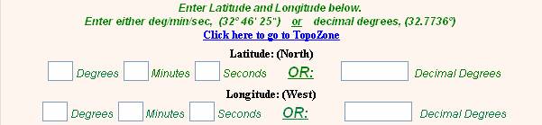
Do not try to enter "degrees, minutes, seconds" into the "decimal degrees" box, or
vice versa. Remember that 32 35' 29" N is NOT equal to 32.3529
degrees N! In fact, 32 35' 29" N equals 32.5914 degrees N (to find out why, click here). Back
to FAQ List
How Will I Know
if My Latitude and Longitude are Wrong?
If you try to enter coordinates into our online data entry form that are outside the
boundaries of the county, or do not correspond correctly to the grid square that you
entered elsewhere on the form, you will receive an error message. In other cases,
you may also receive an email or a phonecall from us to alert you to the problem.
Understanding where you collected your plant specimens is crucial to the scientific
value of our Plant Atlas project, and so we need you to determine the latitude and
longitude of your collection locations as carefully as you can. Keep in mind that
one minute is equivalent to about one mile, so a large error in location can be easily
introduced if you don't record the numbers correctly. The very first time that you
enter data into the system, try not to enter more than a dozen plants, because it
gives us a chance to review your entries. That way, if any issues arise, we can contact
you before you waste your time, and have to go back and correct the data for a large
number of specimens. Back
to FAQ List
What are the
Boundaries of Latitude and Longitude for My Grid Square?
To help you get a handle on it (using the "decimal degrees" coordinate system in this
example) the north boundary of our county is roughly at 33.5051 degrees latitude and
the south boundary is about 32.5344 degrees latitude. Similarly, much of the county
is roughly bounded on the west by 117.2491 degrees longitude and on the east by 116.0805
degrees longitude. Considering that the county is so large (about 4,200 square miles
in size and larger than some states) it may surprise you that the number before the
decimal point doesn't vary much. But in fact, changing from 116 degrees to 117 degrees
in longitude (or 32 to 33 degrees latitude) puts you clear across the county! You
can see that if you make a mistake entering your lat/long into the data entry form,
it can translate quickly into large errors. If you want to understand the boundaries
of latitude and longitude for your particular grid square,
refer to the topographic map that was provided in your handout packet. The lat/long
is marked as tickmarks along the border of the map. Make sure that the map says "NAD
84" on it and it is marked in either decimal degrees (DD.DDDD) or degrees/minutes/seconds.
If it says "NAD 27" on it, or it is marked with the hybrid coordinate format
(DD MM.MM) give us a call and we will print out a corrected map for you. You
can also use the customized link to Topozone on
our website to check the coordinates of the four corners of your square. If you have
any questions, or problems obtaining correct latitude and longitude for your collecting
sites, please contact us by email at plantatlas@sdnhm.org or
call us at 619.255.0298 to ask for assistance. Back
to FAQ List
Why Did I Get
an Error Message When I Entered my Coordinates into the Online Data Entry Form?
Just like there are 60 minutes in each hour, there are 60 minutes in each degree.
Similarly, each minute is divided into 60 seconds. That is why you will get an error
message on our online data entry form if you try to enter a number larger than 59
into the boxes for minutes or seconds. Also, to be certain that the coordinates that
you enter into the online data entry form are within the borders of our county, you
will also get an error message if you try to enter a value for latitude that is other
than 32 or 33 (or if you try to enter a value other than 116 or 117 for longitude). Back
to FAQ List
Can I Use My
GPS to Get the Elevation?
Modern hand-held GPS units often do provide elevation; however, you must be aware
that it is very often not accurate. Most low-cost GPS receivers advertise that they
will provide elevation that is within 50 feet (15 meters) of the actual elevation,
but sometimes the error in the reading will be much greater. The elevation reading
on your GPS at a given fixed point may vary by hundreds of feet - and this is normal,
not a malfunction. On top of that, about one in every 20 times, your GPS will give
you a completely random number, from zero to you-name-it, so please keep this in mind!
You need to be sure that you have a clear and unobstructed
view of the sky, but even if you do, the accuracy may still vary widely because of
random errors caused by atmospheric delay, incorrect satellite positioning, or poor
geometry in the satellite constellation. As a rule, vertical error (i.e., error in
elevation) is about one and a half times that of horizontal error (i.e., error in
position) so you certainly should not trust your elevation readings any more than
you trust your position readings. (To see how to handle this, see the related FAQ
"How Should I Record Elevation in the Field?") Back
to FAQ List
How
Should I Record Elevation in the Field?
Given the error associated with elevation when determined by a GPS, how should you
record elevation? You can go ahead and use your GPS if you wish, but you should take
the time to verify the readings on a map to ensure they are not way off (at least
until you become confident with using your GPS and you clearly understand how it behaves).
Every time you go out in the field collecting, you should be taking along a copy of
the topographic map that we provided in your grid square handout packet. Of course
by now you are in the habit of recording on it a dot for each collection location
(i.e., "collection event"). Elevation is also shown on those maps (and on all USGS
quad maps on which your personalized topo map was based) by contours (lines that are
drawn to join areas of similar elevation). The main contours (dark lines with numbers
written in them) typically are 200 feet apart, and they are separated by four finer
lines that are in increments of 40 feet. With the typical GPS error being (plus or
minus) 50 feet at the best of times, and the smallest contour intervals on topographic
maps being 40 feet, this means that it is not reasonable to record elevation at less
than 40- or 50-foot intervals (or about 15 meters). Even if your GPS gives you a reading
with decimals or in one-foot increments,
in reality we do not enjoy that level of precision. So round elevation off to the
nearest 40 feet if you are relying on the topo map, or 50 feet if you are using a
GPS (e.g., as 2500 ft, or 2550 ft, or 2600 ft, or 2650 ft. etc.). Our online data
submission form takes elevation in either feet or meters, but automatically converts
feet to meters for storage in the database. Back
to FAQ List
Volunteer
Opportunities
What if I Cannot Do Field Work? Can I Still Participate?
Absolutely. Doing the field work is only one component of the Plant Atlas project.
The Botany Department also has a need for volunteers who can work in the herbarium
and mount plants on herbarium sheets for accessioning. You may also work for a company,
or belong to an organization that could benefit our project by donating equipment
and supplies (such as computer equipment, GPS units, cardboard, or promotional materials
like pins, hats or T-shirts), services (like copying and printing), staff time (GIS
work, for instance), or money. You may also be able to help facilitate agreements
for legal access to property, or help us obtain permits. You could also encourage
other people from your school, church, or service club to adopt a grid square and
get involved in the project. Click here for for the online Museum
Volunteer Application Back
to FAQ List
|